September 17-19, 2024: Harmonie State Park (Indiana)
On our drive from Colorado to the Richmond, VA area we decided to take a break at Harmonie State Park in Indiana. The park sits on the Wabash River which forms the border between Indiana and Illinois in that vicinity. The park is about 3500 acres in size (more specifically 3465 acres according to one reference). The campground has 200 sites. The forest is mature so there isn't much undergrowth. This leads to campsites that are well shaded under the canopy but not privacy between camp sites. With 200 sites, there are some with decent privacy but we picked a site in the middle of one of the loops. Fortunately, it was during the week and the off season so the nearest occupied site was several removed from ours and privacy wasn't an issue during our short visit. The table for the camp site behind us was right near our back/only entrance door. Hopefully the following pictures are illustrative.
We arrived early evening on Tuesday and left near daybreak on Thursday so that allowed for park exploration and biking on Wednesday. In addition to roads and paved bike trails there are mountain bike trails. The wife wasn't up for biking so I didn't think it was worth taking all the bikes out to get to my mountain bike which is the last to unload. So I just picked road biking since my road bike is the first to unload. I took a couple of medium length almost duplicate rides, around 16 miles each. Most of each ride was inside the park but about one-third was outside the park.
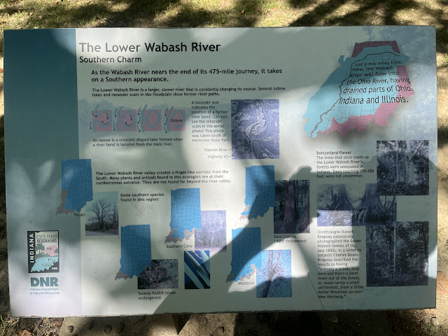
I visited the river picnic area next. The area has vault toilets but surprisingly also has a running water spigot. The area is close to and upriver from the boat ramp area but not right next to it. It also provides a nice view of the river. In this picture, the view is across the river.There was a placard in the picnic area that described the Wabash River. It was in partial shade so my picture lighting is impacted by that. The placard notes that the lower part of the river represents a transition where some southern tree species such as pecan and bald cypress can be found. The river drains Indiana and Ohio and eventually drains into the Ohio River.
 Oil is still present beneath the park. Previous well pumps were used to extract the oil. One of the oll well pumps was painted and preserved as a park attraction. The park mineral rights are owned by a private company. Currently, the oil is extracted by pumping in salt water and forcing the oil to the surface for collection. The preserved well is in the background behind the placard.


Comments
Post a Comment